

By Stephanie Nestor, Assistant Editor, Infrastructure Magazine
With responsibility over key commercial shipping ports, Port Authority of New South Wales (Port Authority) turned to digitalisation to visualise its assets and facilities in a digital twin. This innovative project earned Port Authority an award for digital innovation, with the digital twin enabling remote monitoring, improving understanding of port activities, and driving environmental initiatives.
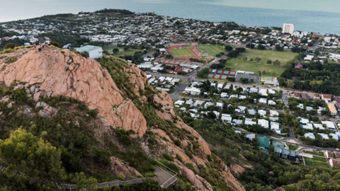
Port Authority is a state-owned corporation that acts as the Harbour Master for NSW’s six commercial seaports, with responsibility over operations, emergency response, security, safety and navigation for commercial shipping in Sydney Harbour, Port Botany, Newcastle Harbour, Port Kembla, Yamba and Eden.
Port Authority’s survey group, based in Sydney, is responsible for all the hydrographic survey and mapping for each of the port sites on the east coast of Australia, which often means time-consuming site visits to inspect assets across the state.
Relying on 2D maps and plans, Port Authority turned to advanced technology to streamline operations and incorporate various forms of data to develop a fully-realised digital twin.
The need for digitalisation
Following the privatisation of landside operations at Port Botany, Port Kembla and Newcastle, Port Authority had teams working across the state on different sites, which only highlighted inefficiencies when it came to sharing data and information.
“Port Authority historically operated with separate systems for different functions, leading to data silos and inefficiencies. Information across various documents and spreadsheets made it difficult to access and analyse data holistically,” a spokesperson for Port Authority said.
“In addition, data was often manually entered into spreadsheets and reports, consuming considerable time and resources.” For example, previously, its ship planning processes involved a labour-intensive procedure where the Harbour Master or their representative would hand draw a ship or use a cardboard cutout onto a paper chart.
The mapping specialist would then need to add the ship into a CAD model to run cross sections at various points along the ship, which was used to assess under keel depth for safe operation in shallow water. Afterwards a paper plot would be discussed and the berth arrangement finalised before approval would be given for the ship to berth.
This lengthy process would take weeks to complete and had to be started months ahead of a ship entering port, further highlighting the need for processes to be digitised and streamlined.
A single source of truth
With more external organisations requiring Port Authority data, there was a clear incentive to streamline the link of information into one easy to use hub. However, gaining an accurate in-depth view of Port Authority’s physical assets is extremely difficult, especially for a business that spans across the entire state.
Port Authority sought to create a dynamic digital representation of its physical assets across six geographically dispersed ports, accessible to multiple departments and stakeholders to improve collaboration, decision-making, and operations, creating a single source of truth with a digital twin.
Port Authority selected Bentley Systems’ ContextCapture to create accurate 3D reality models of the port sites, and OpenCities applications to establish a GIS and digital twin platform for remote asset inspection. Drones were used to capture imagery of the facilities and assets that could be recreated as 3D reality models in OpenCities Planner.
Setting up this digital twin helped streamline workflows and reduce travel between ports by facilitating remote asset monitoring, optimising collaboration and accurate data sharing among departments and stakeholders, which is expected to save 50 per cent in working hours compiling data requests and mapping queries.
Demonstrating successful digitalisation, the project was a finalist at the Bentley Going Digital in Infrastructure Awards 2023 in the Facilities, Campuses & Cities category. “The Bentley Awards bring together leading professionals from across the infrastructure industry. Being a finalist meant having access to cutting-edge ideas, technological advancements, and best practices on the world stage,” Belynda Gibbons a Port Authority spokesperson said.
“Being able to interact with the latest technology, and to talk with passionate people about what other countries are doing in the sustainability and environmental space was definitely inspirational.”
One team, one culture, one port authority
While the maritime sector has historically relied heavily on paper, the rise of digitalisation has greatly improved safety, providing accurate, real-time vessel positioning, and up-to-date charts.
Port Authority’s vision of one team, one port, one culture has informed digitalisation by focusing on implementing systems that can streamline data sharing and encourage collaboration. A Port Authority spokesperson said that the success of digital twins is especially beneficial for companies like Port Authority that have assets spread across a large area, making access for different team members difficult.
“The comprehensive data visualisation and simulation capabilities of the digital twin provides Port Authority with valuable insights to support informed decision-making at all levels, from strategic planning to daily operations,” a spokesperson said.
“The move to GIS has allowed mapping information to be provided to users dynamically, accounting for changes as they occur while keeping a single point of truth. The movement from 2D drawings to 3D models has led to more accurate and intuitive information for users, who no longer need to make abstractions from 2D information.
“The digital twin allows any staff member who needs to find the latest and most accurate information about an asset to do so from wherever they are located. It also allows team members from different ports to collaborate on projects and planning in the same digital space, ensuring they’re using the same information to arrive at the best possible solutions.
“The digital twin can act as a platform for sharing information and updates with stakeholders, including government agencies, port users, and the community. This has increased transparency and facilitated better collaboration on infrastructure projects.

Visualising sustainability
With assets spread across the state, a digital twin becomes a tool to remotely monitor assets and environments to provide a bigger picture. For Port Authority, these digital 3D models and GIS system allow teams to zoom in on the details while also zooming out to consider the local environment.
“Digital twins can be used to visualise and simulate the impact of new developments on existing infrastructure, traffic patterns, and community well-being, which can be particularly beneficial for large-scale projects like smart cities initiatives or urban renewal initiatives,” a spokesperson said.
“By leveraging real-time data from sensors, historical records, and simulations, engineers and project managers can optimise infrastructure placement, resource allocation, and traffic flow, leading to more efficient and resilient infrastructure.”
As these modelling systems draw in data and information from various sources, Port Authority has leveraged the technology to help direct sustainability projects. “The software includes tools for assessing the environmental impact of infrastructure projects, such as energy consumption, emissions, and resource usage as well as model and manage natural resources like water, forests, and protected areas.
“This can help planners design more sustainable projects that minimise environmental footprint and make more informed decisions about resource allocation, environmental protection, and disaster preparedness. “As an organisation, we are also working to achieve ambitious sustainability targets to reduce our environmental footprint.
Our model aims to use digital twins to simulate various scenarios and optimise operations for lower emissions, waste generation, and water consumption and minimise environmental impact.”
The beginning of the digital twin
With the digital twin already proving successful for Port Authority, the next step in its digitalisation journey is to continue developing its 3D models and systems to attain even better accuracy and insights. “The GIS is currently the beginning of a full digital twin,” a spokesperson said.
“In 2024, Port Authority is aiming to capture more 3D reality models using drone flights, iTwin Capture Modeler and link these to the various systems and sensors used across the ports creating a fully functioning IoT ecosystem.”
Digital twin technology has already contributed to a better understanding of these key port assets in New South Wales, as well as driving sustainable initiatives for operations, but this is only just the beginning of innovative visualisation.


